Thursday, October 29, 2009

Mind Map based on 'The Incas' by Terence N. D'Altroy

The great empire of the Incas at its height encompassed an area of western South America comparable in size to the Roman Empire in Europe.

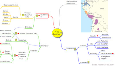
Click the figure below to see the interactive mind map of 'The Incas'.


Mind Map based on 'The Incas' by Terence N. D'Altroy.
Continue reading at:
'The Incas' by Terence N. D'Altroy, Interactive Mind Map

Wednesday, October 28, 2009

Ceramics of Ancient Peru, Interactive Mind Map

When Europeans first entered the Andean area in the early part of the sixteenth century, they encountered the Inca Empire, a vast and powerful political domain that incorporated the largest area in South America ever to have been brought under one ruler.

Click the figure below to see the interactive mind map of the Ceramics of Ancient Peru.


Ceramics of Ancient Peru, Interactive Mind Map.
Continue reading at:
Ceramics of Ancient Peru, Interactive Mind Map

Tuesday, October 20, 2009

Chan Chan: Peruvian archaeologists find 17 500-year-old wood statuettes


The largest Pre-Columbian city in South America, Chan Chan is an archaeological site located in the Peruvian region of La Libertad, five km east of Trujillo.

Click the figure below to see the video.


Chan Chan: Peruvian archaeologists find 17 500-year-old wood statuettes
Continue reading at:
Chan Chan: Peruvian archaeologists find 17 500-year-old wood statuettes

Chan Chan: Peru Travel, Video


The largest Pre-Columbian city in South America, Chan Chan is an archaeological site located in the Peruvian region of La Libertad, five km east of Trujillo.

Click the figure below to see the video.


Chan Chan, Trujillo, Peru
Continue reading at:
Chan Chan Archaeological video

Thursday, October 15, 2009

Chankillo, San Rafael District, Peru and Golden Rectangles

Golden Rectangle
Successive Golden Rectangles dividing a Golden Rectangle into squares.

Click the figure below to see the interactive illustration of Chankillo, San Rafael District, Peru and Golden Rectangles.

Marcahuasi.
Continue reading at:
Fortified Temple of Chankillo and Golden Rectangles.

Tuesday, October 13, 2009

Proto-Quechua, Interactive Mind Map

Quechua is a Native American language family spoken primarily in the Andes of South America, derived from an original common ancestor language, Proto-Quechua. The official language of the Inca empire was Quechua.

Click the figure below to see the interactive mind map of the Proto-Quechua.


Proto-Quechua, Interactive Mind Map.
Continue reading at:
Proto-Quechua, Interactive Mind Map

Quechua Language - Index

The official language of the Inca empire was Quechua.

Click the figure below to see the Index.


Quechua Language - Index.
Continue reading at:
Quechua Language - Index

Quechua song: Chirapaq by Alborada with lyrics

The official language of the Inca empire was Quechua.

Click the figure below to see the video.


Quechua song: Chirapaq by Alborada.
Continue reading at:
Quechua song: Chirapaq by Alborada with Lyrics

Quechua language: Children Singing, Pampa de la Quinua, Ayacucho

The official language of the Inca empire was Quechua.

Click the figure below to see the video.


Quechua language: Children Singing.
Continue reading at:
Quechua language: Children Singing